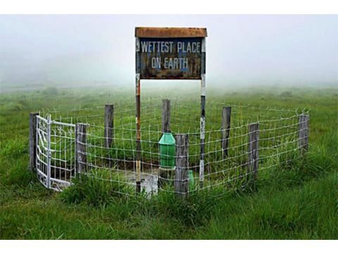
Mawsynram would ask mirror-mirror on the wall, which is their wettest place? There’s been a rivalry for years between the famous Cherrapunjee, the famous neighbour. But Mawsynram rejoiced with the crown of the ‘wettest’ place on Earth. Although as a traveller would experience in your sojourns to Mawsynram remains unchanged. The drive from Mawphlang to Mawsynram was panoramic, with curvy roads, lush greenery & small showers on & off.

The morning in Mawlynnong was a beautiful, clear blue sky, fresh air and sun shining bright. All packed, we droved towards Mawsynram, located at an elevation of 1,400m, which sits atop a crease on the southern slopes of the east Khasi hills. As we drove the routes, the scenic view of waterfalls and the rain-washed countryside were along the way. Ever since the shot to fame after its unique weather pattern, the laid-back village has piqued the interest of many travellers.

I reached a signpost that said ‘Mawsynram Division’, a short distance beyond which I was greeted with light showers. The most exciting thing I observed while travelling through the village was farmers wearing the traditional rain shield, known as Knups while tending to their fields. It was to protect from sun & rain; both were unpredictable in the region.

As I passed through the village, I saw a few locals spend weaving a Knup. My driver confirmed it is a labour-intensive process that takes at least an hour to complete. And keeps the village’s women occupied throughout the rainy season. Since bamboo and broom grass are among the chief plants grown in Meghalaya, bamboo baskets, brooms and Knups are made by each household.

Although Mawsynram was a day excursion, I recommend spending at least a night or two to experience and enjoy the local culture and ambience. Upon reaching, I saw the village comprises 100-odd households, so I decided to stroll around the area. The ‘Maw’ in Mawsynram is a Khasi word which means ‘stone’. While chatting with the locals, I found that the village is for a Shivling. Post following the direction, I witnessed the gigantic formation of a stalagmite, which resembles the shape of a ‘shivling’. It was pretty interesting!.

Further walking off the village centre stands the elegant façade of the Church of God, near a football ground. A short distance from the football ground lies the Presbyterian Church, which has an austere yet stately exterior. And that’s the end of Mawsynram. I decided to sit for a while and soak in the beauty of this tiny village.

And while watching the time passing slowly, people are busy doing their daily chores. I enjoyed a typical Khasi snack: Pusaw (steamed rice cake flavoured with orange rind) and Sha Saw (red tea).

We drove towards our last destination before heading towards Shillong Elephant Falls. It’s a 1hr 30min drive, approx 48 km. This breathtaking Waterfall is locally called ‘Ka Kshaid Lai Pateng Khohsiew,’ which translates to ‘The Three Step Waterfalls’. The Waterfall results from a mountain stream scything through the forested slope and drops over multiple levels. Upon reaching, I saw a queue of cars lined up near the falls.

And interestingly, the railed approx 150 steps walkways begin from the head of the falls and continue to the bottom. Ensuring that I not only see the magnificence of the falls but also feel the cool water’s spray and the thunderous sound of the flow. The temperature kept dipping as we walked each step. The Elephant Falls was named by the British due to an elephant-shaped rock on one side of the Waterfall. However, the 1897 earthquake destroyed the stone.

Interestingly! Elephant Falls shares its name with another well-known waterfall in Vietnam’s Da-Lat area. British troops called this Waterfall the most famous Waterfall during the colonial period. Though the colonial era was over, the term lingered. However, the leftover granite has since dissolved owing to the constant assault of water dripping from a high altitude.

As I walked, I saw the first step of the Waterfall was significant and slow, buried in the lush woodlands all around. While the second step, however, lacks the massive drop and is frequently hidden from public view. At the end is the pool, a tranquil spot with knee-level clear water and a giant cascade in the background. As I walked around, I realised the terrain, studded with streams and falls, was perfect for numerous small hiking paths. However, the sights kept me busy taking shots from my camera. But if you visit, try the hike around the waterfalls concealed amidst the dense woodlands.

After wandering for a good time, I drove to Mawphlang- the Sacred Groves.
By Air:
The nearest airport to Guwahati. A cab can be booked outside the airport to reach Shillong. It would be best if you changed the cab from Shillong to Mawsynram or Elephant Falls.
By Rail:
Guwahati Junction railway station is well connected with most of the cities of India. Upon reaching, one can book a cab to Shillong; from Shillong, a different cab has to be taken for Mawsynram or Elephant Falls.
By Road:
Private cabs or shared taxis of Guwahati regularly ply to Shillong. One has to change the cab in Shillong to reach the destination in Meghalaya. You cannot drive since a private vehicle is not allowed.